I use Earth observation and geoinformation to enhance food security, focusing on spatial models and analytical methods to assess the location, timing, scale, and dynamics of food production and distribution.
I have contributed to capacity development in the geo domain through research, education, and policy support since 1996. My work has four areas.
1 Establishing and nurturing diverse communities: I coordinate research, education, and capacity development projects related to food security and the environment, funded by organisations such as the European Commission, Nuffic, BMGF, and FAO. Since 2000 I coordinate GEM, a long-running Erasmus+ MSc programme on EO and GIS for environmental modelling and management with 340+ graduates across 75 countries. As co-founder of Geoversity, a lifelong learning platform partnering with NASA SERVIR and NSO, I promote accessible geo-education for all.
I contribute to the development and support of open access datasets, models, and resources, enhancing global understanding of food systems. I created the first global accessibility maps [1, 2, 3], now a widely used concept and data source for resource management in an increasingly connected world. I coordinate the GEOGLAM Guidance Document for Capacity development [4] a 30 author collaboration to support the development and design of impactful interventions.
2 Generating social and economic benefits: My capacity development work leverages EO and spatial information to improve food security and address challenges in resource sustainability and food system resilience. I led the development of PRiSM, the Philippines' national rice monitoring system, which is now embedded in the Department of Agriculture’s operations, providing early warning of typhoon impacts and seasonal rice area/yield data. I also developed the first version of JRC’s Digital Observatory for Protected Areas (DOPA) to monitor and report on the state and pressures of protected areas for policy, funding, and management.
3 Influencing long-term policy development: My contributions to crop health, physical access to resources, and food transport network resilience have featured in flagship policy reports for the World Bank [5, 6] and FAO [7], as a means to influence policy development through Earth observation-related advocacy. This has spun off into development projects by FAO and USAID.
4 Advancing new products and methods: Through projects and mentoring 20 PhD candidates with fellow supervisors, I help develop RS-based methods to extract information on food production systems and the environment. I collaborate globally in my research for impact (around 80% of my publications are international collaborations and are in the top 25% cited worldwide [Scopus]). I use EO and spatial thinking to explore research questions on resource sustainability and food system resilience. Several studies by PhD candidates have earned awards for innovation, including assessments of crop lodging [8] and heat stress effects on productivity [9]. I contributed to the first global assessment of pests and diseases on crop health [10], a widely cited study.
I have made these contributions through a career of active engagement in regional and global communities for capacity development, education, policy support, and research. I have held positions in CIAT in Colombia, the World Bank in Washington DC, the Joint Research Centre (JRC) of the European Commission in Italy, IRRI in the Philippines. Since 2015 I am a Professor in Food Security in the Natural Resources department at ITC in the Netherlands to support its mandate for global capacity development in the geo domain through education and research. I have been active in GEO since 2010, first with AsiaRice and since 2015 with GEOGLAM. I am a Fellow of the Royal Geographical Society.
Expertise
Earth and Planetary Sciences
- Datum
- Rice
- Model
- Sentinel-2
- Investigation
- Remote Sensing
- Area
Agricultural and Biological Sciences
- Crops
Organisations
Ancillary activities
- 4TUSteering Group member
- GEOGLAM (GEO)Executive
- Nature SpringerEditorial Board of an academic journal
- Royal Geographical SocietyMembership
I am based in the Natural Resources department at ITC. My work – with students and colleagues at ITC and around the world - concerns the following questions that are embedded in some of society’s greatest challenges.
1 Where, when, and how is food produced?
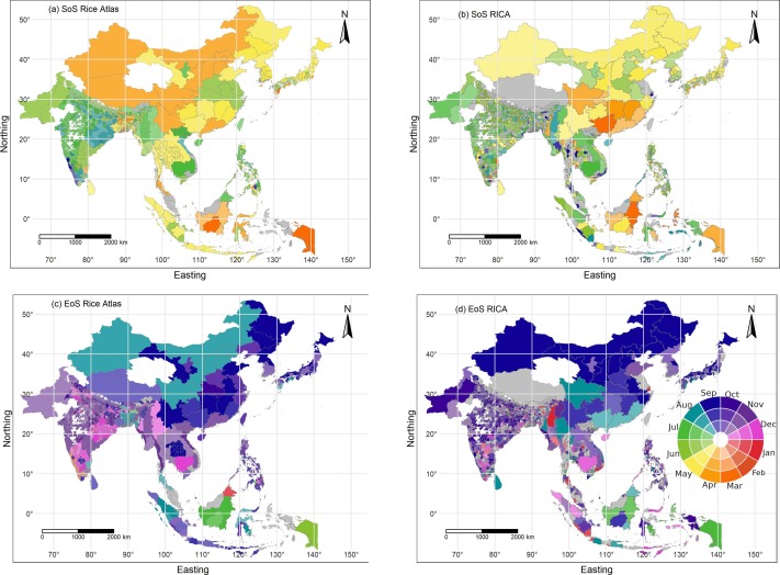
Crop calendars - showing where and when crops are planted and harvested - are one of the most essential pieces of information for understanding global food availability. It allows to understand when food is produced, when it is likely to enter into the market and can be used to estimate the impact of disruptions to supply. We work on remote sensing-based methods that can automatically extract information on planting and harvesting dates for specific crops from Earth observation satellite imagery. This example for rice in Asia shows that our methods can be used to develop unique datasets of start and end of season dates (SoS, EoS) covering huge geographic areas and diverse environments and crop management practices [paper].

2 How much is produced, what are the risks to production, and how can these risks be mitigated?
Crop production is limited by droughts, excess rainfall and high/low temperatures. These perils are an increasing to risk to many farmers around the world, threatening their livelihoods and food security in general. Colleagues in the NRS department, like Kees de Bie work on geodata models that are actively used in drought peril insurance Ethiopia to insure the pre-season loans of smallholder farmers. Hypertemporal information on vegetation greenness is the basis for determining payouts to insured farmers. This work has been supported by the Netherlands Space Office and the European Commission.
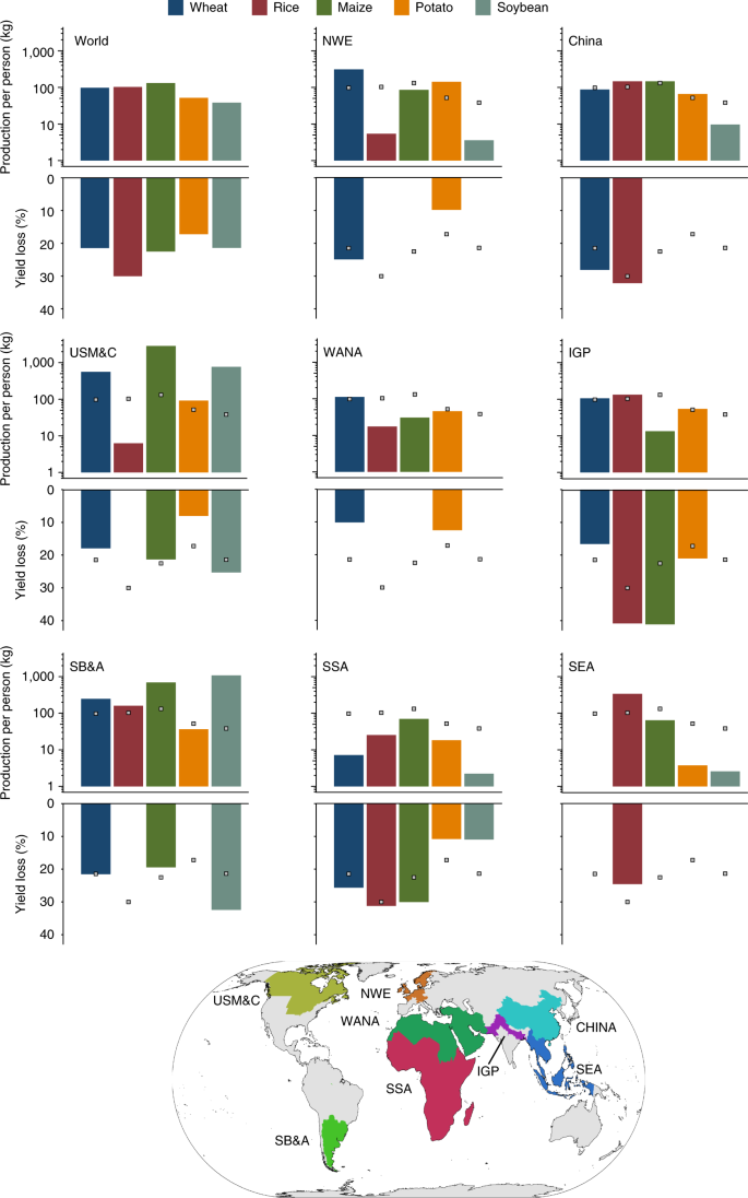
Crop production is also reduced due to crop pests and pathogens and lodging. In a recent global study we estimated that 20 to 30 percent of global food production for five major crops - wheat, rice, maize, potato and soybean - is lost to pathogens and pest. I am also interested in how we can better collect and use information to inform ourselves and act upon crop health issues [link]. Future work will look at how we can couple models of pest epidemics and losses.

3 How do food and people move from A to B and what happens in the event of disruptions or changes to our food transport network infrastructure?
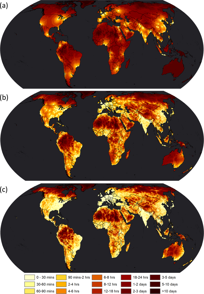
One of my long-term interests is the use of spatial accessibility models to estimate travel time and to do this in a robust way for both local and global analyses. Accessibility is one the dimensions of food security, but it is also an important consideration for understanding the inequality in access to education, healthcare and employment opportunities. I have co-authored several publications [link, link, link, link] on this accompanied by open access datasets and code - and some nice looking maps too :).

These are quite diverse questions, which have evolved from my background in geography, which is like having a licence to study anything, anywhere. My contributions to these research areas have featured in The Economist, New Scientist, Nature, and Science as well as in flagship policy reports for the World Bank and the Food and Agriculture Organisation of the United Nations (FAO). A fuller list is here.
My research is often conducted through the co-supervision of MSc and PhD students, and you can find out more about these exciting projects here.
I am a Senior Editor for the journal Food Security.
Publications
2025
2024
Research profiles
I coordinate the Erasmus+ MSc in Geo-information Science and Earth Observation for Environmental Modelling and Management (GEM).
I lecture and supervise MSc students on Food Security in both the M-GEO and Spatial Engineering MSc programmes at ITC. I also co-developed the concept of, and provide content for Geoversity.
Affiliated study programs
Courses academic year 2024/2025
Courses in the current academic year are added at the moment they are finalised in the Osiris system. Therefore it is possible that the list is not yet complete for the whole academic year.
Courses academic year 2023/2024
I coordinate several research, education and capacity development projects related to food security and the environment. These are kindly funded by the European Commission, Nuffic, the Bill and Melinda Gates Foundation, and FAO.
I have several roles that relate to the three pillars of ITC. With respect to research, I coordinate the research programme within the EENSAT project (Ethiopian Education Network to Support Agricultural Transformation.
I am a member of the Steering Group for the 4TU Centre for Resilience Engineering (4TU RE) in the Netherlands.
In terms of education, I am the coordinator of the Erasmus+ MSc in Geo-information Science and Earth Observation for Environmental Modelling and Management (GEM).
I am co-chair for Capacity Development in the Group on Earth Observations Global Agricultural Monitoring Initiative (GEOGLAM).
I am also a Fellow of the Royal Geographical Society.
You can find more information about my work in the media here.
In the press
Food security
Yield Sensitivity of Modern Rice Varieties to Warming Temperatures:
Crop health
The global burden of pathogens and pests on food crops
Mapping inequality in accessibility
Address

University of Twente
Langezijds (building no. 19), room 1105
Hallenweg 8
7522 NH Enschede
Netherlands
University of Twente
Langezijds 1105
P.O. Box 217
7500 AE Enschede
Netherlands