I am an Assistant Professor at the Faculty of Geo-Information Science and Earth Observation (ITC), University of Twente. I hold a Ph.D. in Photogrammetric Engineering from the University of Tehran and have extensive experience in UAV-based remote sensing, Geo-AI, and image analysis for environmental and agricultural applications. My academic journey includes appointments in Iran, Belgium, and the Netherlands, with a strong focus on interdisciplinary research and challenge-based education. I have supervised numerous MSc and PhD theses and have published widely in international journals and presented at various international conferences. My current research explores the integration of geospatial technologies and machine learning for addressing global challenges through local actions in air quality, precision agriculture, scene computer vision, robotics, and 3D modeling.
Specifically, I am working on multi-scale data fusion—integrating satellite-, drone-, and ground-based observations—to enhance the detail and accuracy of extracted information. In particular, drones play a crucial role in bridging ground-based and spaceborne observations, helping to fill gaps in low boundary layer measurements.
Expertise
Earth and Planetary Sciences
- Unmanned Aerial Vehicle
- Satellite Imagery
- Pilotless Aircraft
- Spatial Resolution
- Remote Sensing
- Quality Control
Engineering
- Point Cloud
Computer Science
- Convolutional Neural Network
Organisations
I hold a PhD and MSc in Photogrammetry and Remote Sensing from the University of Tehran, the top-ranked university in Iran. Currently, I serve as an Assistant Professor in the Department of Earth Observation Science (EOS) at the Faculty ITC, University of Twente. My work bridges drone technology and AI to advance geoinformation science, with a strong focus on tackling global challenges—particularly those facing the Global South.
Supervision of graduate students
Currently, I am supervising three PhD students (two will defend in early 2025, and one has recently accomplished his qualifier at the University of Twente), two master's students, and two master's internship projects. In addition, I have supervised three graduated PhD students (one has continued as an assistant professor, one is a scientific researcher, and one has just graduated and plans to start a post-doc position after her parental leave). Across my career, I have supervised more than 25 master's and five bachelor's students.
Research achievements
Throughout my career, I have been driven by a passion for leveraging technology to address real-world challenges. My overarching vision is to create innovative solutions that combine and harness the power of unmanned aerial vehicles (UAVs/drones), data fusion, and artificial intelligence (AI) to advance our understanding of environmental systems and improve societal well-being. This vision has guided my journey, from my early fascination with UAVs and their potential for Earth observation, to my dedication to advancing data fusion and AI techniques. During my PhD, I focused on using UAVs and multi-sensor data fusion, exploring how integrating diverse observations can enhance accuracy and resource utilization. This work resulted in over 10 published articles and laid the foundation for my further research career. My interest in UAVs began 14 years ago at an airshow, where I was captivated by their potential to transform environmental observation. Since then, I have dedicated significant efforts to developing UAV systems, equipping them with innovative sensors, and applying them to variant applications—work that has yielded over 20 publications and numerous successful student theses. I was also involved in a drone based mapping software development team, and the scientific solution I proposed for plant protection at the national level for the first time was greatly applied for pest/stress detection and appreciated by FAO. Six years ago, I began integrating AI into my research as a transformative tool for modelling and information extraction. This interdisciplinary approach has led to significant advancements, with over 10 publications and the guidance of multiple graduate students in applying AI to real-world problems.
Editorial Roles
- Editorial board member, Drones journal, MDPI
- Guest Editor: Special issue “Advances in Remote Sensing of Geophysical Surveys Based on UAV,” Remote Sensing Journal
- Topical Advisory Panel Member: “Drones in Agriculture and Forestry,” Drones Journal
- Associate Editor and Editorial Board Member: GIScience Journal
Invited Academic Roles
- External Examiner for PhD Thesis: University of Cape Town, South Africa
- External PhD and Master student Supervisor: SUNY College of Environmental Science and Forestry (USA), Ghent University (Belgium), University of Tehran (Iran)
- External Bachelor Thesis Examiner: TNW Faculty, University of Twente, Netherlands
Recognitions and Invitations
- First Author of a Journal-Featured Paper Selected for Reader Engagement
- Invited Author: Five papers in high-impact journals in Photogrammetry and Remote Sensing with full APC waiver
- Invited Speaker at (1) the 2nd Global Photonics, Optics, and Lasers Conference (GPOLC2025) and (2) the Global Conference on Mechanical and Aerospace Engineering (GCMAE2025; included paper registration and accommodation discount)
- Webinar Organizer: “NERF and AI for 3D Modeling”
Consulting and Evaluation
- Consultancy Provided: Research and development projects for industrial companies
- Patent Reviewer and Evaluator
Journal Reviewer:
- Trans. on Geoscience and Remote Sensing, IEEE
- Environmental Monitoring and Assessment, Springer Nature
- ISPRS Journal of Photogrammetry and Remote Sensing, Elsevier
- International Journal of Digital Earth, Taylor & Francis
- Scientific Reports, Springer Nature
- Remote Sensing, MDPI
- Remote Sensing of Environment, Elsevier
- Journal of Selected Topics in Applied Earth Observations and Remote Sensing, IEEE
- Air Quality, Atmosphere & Health, Springer Nature
Scientific Committee Membership
- 45th EARSeL Symposium, 2026
- 3D GeoInfo | Smart Data and Smart Cities | LADM & 3D, 2026
- ISPRS Geo-Spatial Week (GSW 2025, 2023)
- SEFI Annual Conference 2024
- ISPRS Technical Commission IV Midterm Symposium 2024
- IEEE International Geoscience and Remote Sensing Symposium 2024
- International GeoSpatial Conference 2022
Publications
2026
2025
2024
Research profiles
Courses academic year 2026/2027
Courses in the current academic year are added at the moment they are finalised in the Osiris system. Therefore it is possible that the list is not yet complete for the whole academic year.
Courses academic year 2025/2026
Courses academic year 2024/2025
Current projects
HealthyWatersIntegrated: Strengthening water and health security in Europe’s marginalized communities through integrated social, geographical, medical and technological approaches
(WP-Leaser)
The project targets water insecurity and related health risks among marginalized Roma communities in Europe, who often lack access to safe water, sanitation, and waste management. Due to their invisibility and limited data, interventions are challenging. The aim is to improve information gathering and create an innovative assessment system combining social, medical, geoinformation, and earth observation methods.
In this project, as the Geomatics work package leader, I used drones to acquire thermal and RGB images, which were then processed to generate orthophotos and point clouds. Combining these data with fieldwork and available maps enabled a comprehensive study of changes within the Roma community, an exploration of settlement patterns compared to typical communities, waste analysis, and change detection.
Finished projects
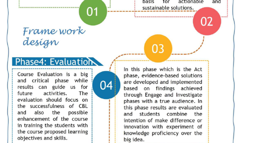
A Challenge-based Learning Framework Design and Practice for UAV Photogrammetry (CBL4UAV)
CBL4UAV
(PI)
The massive introduction of UAVs in our society has made these platforms and their data collection a very popular subject for education in a wide number of institutions (universities, life-long learning centers, applied-sciences, etc.) all over the World. Experts in agriculture, urban planning, mining, disaster management (just to give an example) are using UAV for data collection and information extraction: however, these professionals often operate without having any specific education in photogrammetry (and often without being aware of using it). Increasing the awareness for photogrammetry in these communities with some basic but essential concepts would be beneficial for its correct use. To be successful, these education modules would need to be embedded in an educational framework closer to their professional interests, different from traditional teaching methods. In this regard, Challenge Based Learning (CBL) looks a promising solution for this purpose as it can perfectly tailor the content for different backgrounds and needs. CBL is a collaborative learning experience where students and teachers work together to propose solutions to real-life problems, becoming a valid alternative for traditional education methods especially for students from other domains. This Educational and Capacity Building Initiative project aims at delivering guidelines on how to deliver UAV photogrammetry education in a Challenge-Based Learning framework for our community. The guidelines will be organized according to written texts, micro-lectures, and webinars. In addition, the project will fine-tune this educational methodology on a real pilot course to point possible problems out in the early stage and give a practical example to our community.
EDU-UAV photogrammetry: current online educational landscape
(Co-PI)
This project, titled "UAV Photogrammetry Current Online Educational Landscape", funded by the ISPRS Capacity Building Initiative 2024, is carried out by the ITC faculty team at the UAV Center. The project focuses on the growing field of UAV photogrammetry, a vital tool for disaster management, food security, and mapping applications. As demand for online education in this area increases, the project addresses the challenge of navigating the vast array of available resources. Our team has compiled a comprehensive inventory of UAV photogrammetry courses, categorized by educational level, and evaluated relevant UAV datasets and software tools to support both training and professional applications.
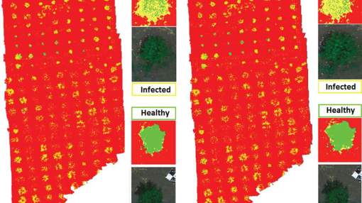
UAV-based plant disease monitoring system
(PI)
The project investigates the applicability of UAV-based multispectral imagery for plant detection and early diagnosis in orchards. It is a national-level initiative funded by the Iranian Plant Protection Organization. We examined various orchards across different locations and environmental conditions, focusing specifically on detecting citrus greening.
Challenge-based learning for teaching UAV photogrammetry in food security
(PI)
Awarded by ECIU, this project applied challenge-based learning to develop a food security course focused on global challenges and local actions in Africa.
Address

University of Twente
Langezijds (building no. 19), room 1221
Hallenweg 8
7522 NH Enschede
Netherlands
University of Twente
Langezijds 1221
P.O. Box 217
7500 AE Enschede
Netherlands
 Scan the QR code or