Research
Léon focuses on the role of digitalisation in the management of infrastructure, particularly buried utilities. His research includes technology development and studies of the impact of innovative technologies for mapping, modelling, monitoring, visualising, and predicting infrastructure behaviour. Practitioners play a pivotal role, which means Léon often employs action-driven interventionist approaches like Design Science Research. His research is mostly user-centric, focusing on how technology can (or cannot) support or streamline stakeholders' activities and key decisions.
Léon is the research lead of ZoARG|ReDUCE, the national industry-driven programme aimed at the Reduction of Damage to Utilities and Careful Excavation. The programme started in 2014 and has expanded in 2025 into a programmatic national initiative, endorsed by many organisations in the excavation and utility sector.
He is Associate Member of the American Society of Civil Engineers, a member of the Executive Committee of the Association of Researchers in Construction Management (ARCOM), coordinator of the 4TU Domain Acceleration Team on Digitalisation in the Built Environment, and a co-founder of the initiatives UT FieldLab and DSI Digital Twin Geohub.
Confidential Counsellor
"I have had the privilege of working with many professors, scientific advisors, staff, and postgraduate students. While our academic workplace often brings exciting and enriching experiences, it can also present challenges, stresses, and unwanted events. I find it very important to provide collegial aid in such situations. Therefore, I am one of the UT confidential counsellors for undesirable behaviour (sexual harassment, aggression and violence, bullying, or discrimination). Any PhD/EngD, support or scientific staff experiencing undesirable behaviour from a colleague can come to me*.
You can contact me directly by phone (6857), Teams, or email. Confidentiality is of the utmost importance, which means our meeting will not be recorded or registered, and you do not need permission from anyone to visit me. I will provide a listening ear, support in finding interventions, and aftercare in (often emotional) cases. *If believe that you or the complainant know(s) me too well, you can also decide to visit my colleague counsellors".
Expertise
Computer Science
- Ontology
- Domain Ontology
- Digital Twin
- Location Data
- Simulation Tool
Social Sciences
- Dutch
- Economic and Social Development
- Supply Chain Management
Organisations
Publications
2026
2025
2024
Research profiles
Léon teaches on the topics of Smart Cities, Digitization in Construction, Construction Innovation, and Coordination of Underground Utility Construction
Affiliated study programs
Courses academic year 2026/2027
Courses in the current academic year are added at the moment they are finalised in the Osiris system. Therefore it is possible that the list is not yet complete for the whole academic year.
Courses academic year 2025/2026
Courses academic year 2024/2025
One of the main issues during society’s transition toward smarter cities relates to the maintenance and upkeep of public infrastructure. It becomes more complicated, for example, to add new networks (e.g. fiber optics, smart grids, submerged waste transport etc.) and maintain existing buried utilities. Besides the physical limitations, information uncertainty (inaccurate or incomplete maps) and coordination issues caused by privatization make add more complexity to execution of inner city streetworks. The ZoARG | ReDUCE research programme that I lead aims to study and improve the existing situation by. Key research activities are centered on information, coordination and supporting technologies. Currently, we have a growing research and industry consortium that collaboratively:
- Identifies how subsurface information can be effectively modelled to support life cycle decisions;
- Further develops and implements subsurface mapping technologies, practices, and codes;
- Implements detection and information solutions in practice to iteratively improve the tools, engage practice in advancing the field of smart inner city engineering, and develop new education curricula for inner city engineering.
Current projects
TISCALI
Technological Innovation for Sewer Condition Assessment Long Range Information System
Finished projects
Spy the Underground
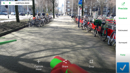
Developing 3D data models for visualization of utility data uncertainties
The ambition of this project is to provide a solution to the varying levels of certainty of underground utility location information. To date, this ambiguity hampered registration of most 3D coordinates on maps. We therefore aim to extend 2D-CAD utility maps (KLIC-melding) with fuzzy 3D information about depth- and geometry of utilities, to achieve an enriched 3D view on the subsurface.
ExcaSafeZone
Developing a prototype urban heat maps for safe excavation
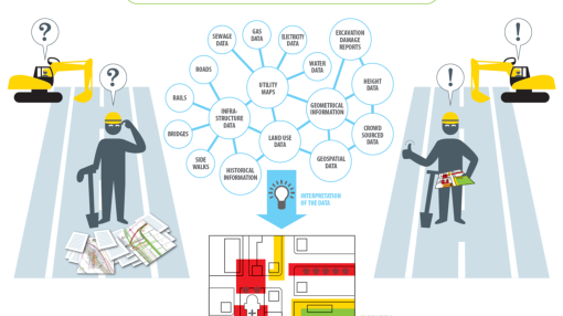
ExcaSafeZone’s objective is to develop an automated system that generates excavation safety maps to enable urban planners, contractors and excavator operators to make more informed decisions about where and how to conduct excavation activities safely. We propose using the promising Linked Data techniques to integrate relevant data sources from public agencies and the web (e.g. Cadastral maps, utility maps, images, soil information, height maps, and historical information). Next, we consult experts to define logical rules for extraction of safety risk information from the linked data. The linked data combined with expert knowledge help define the safety levels for excavation activities on a particular construction site. Eventually, this culminates in a prototype system that creates Excavation Safety Zones based on available linked data, contributing to better excavation planning and, reduction of excavation damage.
Address
University of Twente
Horst Complex (building no. 20), room Z233
De Horst 2
7522 LW Enschede
Netherlands
University of Twente
Horst Complex Z233
P.O. Box 217
7500 AE Enschede
Netherlands
 Scan the QR code or